 |
|
|
|
| Airport/Facility Directory (A/FD) | ||||
 |
 |
|||
| Pocket PC | Smartphone | |||
|
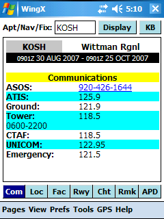
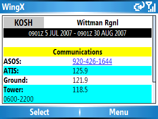
Communications Information with Auto Dial The Communications Page includes frequencies for airports and navaids. The airport display include AWOS, ATIS, Clearance, Ground, Tower, CTAF, Approach and Departure, and Emergency frequencies. A great feature in WingX is the single-tap Auto Dial functionality. Simply tap on the phone number and Pocket PC Phone Edition devices will automatically dial that phone number. |
|
Location Information with Active Links Important location information is shown on the Location page. The basic information includes the state, nearest city, latitude,longitude, elevation, and magnetic variation. In addition, WingX shows the three closest public airports, VORs, and NDBs. The closest airport list shows ATIS/AWOS frequency, as well as the bearing and distance the airport. The three closest VORs and NDB are shown with their navaid frequency, as well as bearing and distance to the navaid. The closest airports,VORs, and NDBs are actively linked meaning that a single tap on the relevant identifier shows A/FD information for that entity. |
|
Facilities Information The Facilities page shows the availability of fuel type, airframe repair, powerplant repair, bottled oxygen, and bulk oxygen. |
|
Runway Information The Runway page shows extensive information about all the runways at an airport. Each runway is first shown in a summary mode that provides only the most basic pieces of information. These pieces of information includes the runway dimensions, the runway surface and condition, as well as the type of runway edge lighting. In addition to the basic information, WingX displays detailed runway information that includes the runway alignment, elevation, types of marking, approach lighting, runway lighting, glide angle, runway gradient, as well as a list of instrument approaches to that runway. The approach names are active links so tapping on an approach name will display that approach chart. |
|
Chart Information The Chart page lists all the charts available for the airport. The charts include the Airport Diagram, Departure Procedures, Instrument Approach Procedures, Minimums, and STARs. All chart names in the list are active links so tapping on an name will display that chart (Premier Edition required). so that tapping on a chart name |
|
Remarks Remarks such as birds on an in the vicinity of the airport, phone pole 1 mile south, portions of a runway not visible from the tower etc are shown here. |
|
Runway Layout (APD) The Runway layout option display the runway layout which is rotatable by dragging the stylus/finger around the screen [Pocket PC] or by using the arrow keys. |
Note: Images on this website may be slightly different to what you see on your Microsoft Pocket PC 2002, Microsoft Mobile 2003, Mobile 5.0, or Mobile 6.0 device. Disclaimer: 14 CFR 91.3 says that you, the PIC, are responsible for the safety of the flight. WingX products are intended to assist you in your preflight and inflight activities. While Hilton Software makes every effort to ensure the accuracy of its calculations and data, Hilton Software cannot absolutely guarantee the accuracy. By using WingX products, you agree to hold harmless Hilton Software and those persons acting on its behalf for any and all, but not limited to, liability, bodily injury, and/or property damage arising from the use of WingX products.
Copyright © 2003-2007 Hilton Software LLC All rights reserved. |


