


 ™ ™ | WingX Pro7 |
New! - traca™ Technology (patent pending)
traca™ Technology Video - definitely a must watch!
We're looking for excellent mobile developers. Be aware, we have very high standards. We prefer engineers who are pilots, but that is not required. iOS knowledge is a plus, but mobile experience is essential. In addition to iPhone, iPad, and Android development, we have some amazing things in our labs.
954-323-2244 10am-6pm ET Retrieve password Approved on iOS 10.3.2 ADS-B Weather and Traffic available now  Click for iTunes Android and Fire Available now!  Pricing
WingX Pro7 is free for CFIs and United States Military! Click here for more info Subscriptions can be shared on iPad, iPhone, Android, and Fire Best iPad App  |
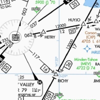
 |  | VFR Sectionals can be zoomed and pinched, they are seamless across the whole US. But that's not all, WingX Pro7 can display terrain that's above you - will you get over that ridge? | ||||||||
 |  | IFR Low/High Enroute Charts can be zoomed and pinched. Just like the VFR Sectionals, they are seamless across the whole US. And yes, you guessed it, the terrain can be displayed to show terrain that you're gonna hit while getting vectored around or starting your descent too early. | ||||||||
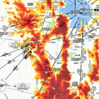
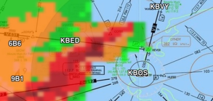 | ADS-B NEXRAD is seamlessly overlaid on Sectionals, or IFR Enroute charts. This real-time in-flight weather information is an amazing addition to the moving map. Of course, moving map screens with ADS-B NEXRAD can be pinch, zoomed and panned. | |||||||||
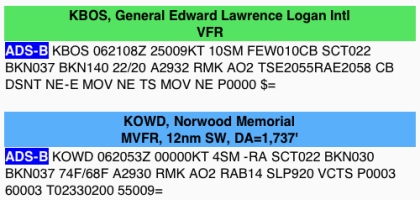 | ADS-B METARs, TAFs, NOTAMs,PIREPs, and AIRMETs appear right on the moving map page. Don't be surprised when you get to your destination and the weather isn't what you had expected or perhaps a runway was closed. Get the latest AIRMETs and PIREPs for your flight and know the unexpected. | |||||||||
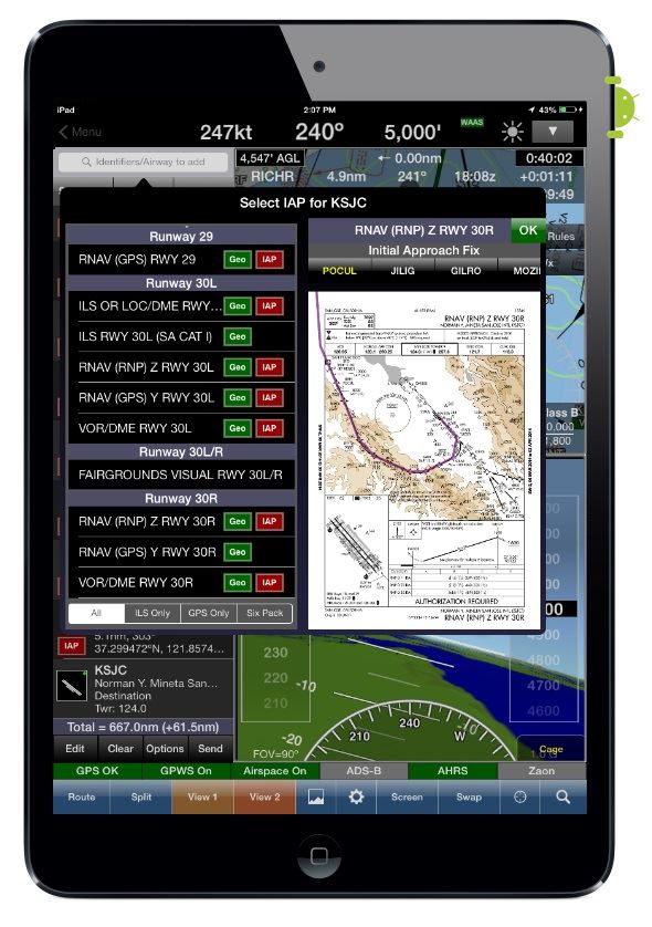
 | Geo-Referenced Approach Chartsfit seamlessly into the moving map. WingX Pro7 uses our own comprehensive and accurate geo-referencing data for the most accurate aircraft positioning possible. When you are getting vectoring around in the muck, wouldn't you like to know exactly where you are? The Advanced IFR option includes IAP geo-referencing and our IAP Routing capability. | |||||||||
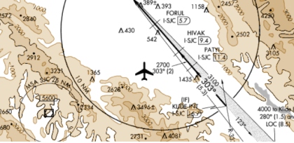
 |  | TFRs (Temporary Flight Restrictions) are displayed right on the Moving Map. So are Special Use Airspaces (SUA) - and you simply tap on them to get the altitudes, effective dates and times, frequencies and other pertinent information - isn't this better then trying to find all that small print on your sectional listing this info? | ||||||||
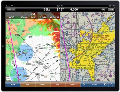 | Dual Moving Maps enable you to monitor your flight as if you have two moving map devices. How cool is that? You can display a sectional and an IFR enroute, or two sectional with one zoomed in and one zoomed out, or an IFR enroute and a geo-referenced approach chart. | |||||||||
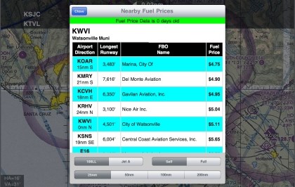 | Fuel Prices are stored on your device and can easily and quickly be reviewed in flight with no Internet connection. WingX Pro7 does all the work for you by finding the cheapest fuel prices and sorting them in order of prices based on your distance from an airport or other point on the moving map. Save hundreds of dollars per year on those cross country flights. Image how much you could save on your flight to Oshkosh. Note: No Internet connection required to view prices - yes, you can search for the cheapest fuel prices while flying at any altitude. | |||||||||
| Zaon Traffic Integration enables traffic threats to be shown on enroute charts. WingX Pro7 inroduces symbology making it easier to interpret. Here's how to interpret the symbology:
Caution: Zaon are no longer in business. At some point we may have to drop support for Zaon products. | |||||||||


